
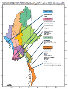
 The Rakhine Coastal Zone is bounded by the Bay of Bengal in the west and has a total land area of 367,780 sq.km. The mountain ranges within the state stretch from Bangladesh to the Chin State and slope downwards from north to south having average elevations of about 900 meters.
The Deltaic Coastal Zone consists of the entire river – mouth areas of three major rivers, Ayeyarwady, Sittaung and Thanlwin. Administratively, this coastal zone lies within Ayeyarwady Division, Yangon Division and Mon State.
The Taninthary Coastal area is the longest coastal zone of Myanmar and is bounded by Andaman Sea in the west. This coastal zone covers south of the Gulf of Mottama upto the mouth of Pakchan River.
National Report of Myanmar, Sustainable Management of The Bay of Bengal Large Marine Ecosystems PDF